
 Yahoo TV
 Satellite Imagery Captures Extent of Earthquake Devastation Across Southern Turkey
9,763 次觀看・1 年前
Satellite imagery captured on Wednesday, February 8, across multiple cities in Southern Turkey showed the after effects following the catastrophic earthquake which struck the region on Monday.
The imagery shows severe damage in Antakya, Osmaniye, Kahramanmaras, Adiyaman and Gaziantep, as well as aid tents.
The combined Turkish and Syrian death toll rose to above 12,000, with the United Nations’s aid agency saying it expected the number to surpass 20,000. Credit: Maxar Technologies via Storyful
相關影片推薦
 2:139歲小學生發現千萬年前大象化石 德國最大陸地哺乳動物「以為是木頭」Yahoo奇摩(國際通)20,079 次觀看・15 小時前
2:11
一早被錢砸醒!網友PO出戶頭明細表 00919季配息11萬多民視影音6,354 次觀看・13 小時前 1:47導盲犬界超級「狗爸爸」英國九歲黃金獵犬培育323隻後代Yahoo奇摩(國際通)7,415 次觀看・15 小時前
1:46
6人花3萬吃過期肉 和牛EMPEROR強硬聲明:不會賠償東森新聞影音45,377 次觀看・11 小時前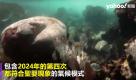 2:15第四次珊瑚白化正式降臨 史上最嚴重 專家憂已達「臨界點」Yahoo奇摩(國際通)14,697 次觀看・17 小時前
1:52
宜蘭奇景! 5層樓民宅竟裝20冷氣機 鐵捲門裝陽台東森新聞影音244,025 次觀看・1 天前2:11
Rosé暴瘦粉絲超心疼:手都在抖... EXO伯賢「保持社交距離」秀敏霸氣拉過來!娛樂星聞2,281 次觀看・13 小時前2:01
前夫放話嗆處理新男友 26歲前妻負氣從台64線墜地亡民視影音30,103 次觀看・3 天前1:43
英籍單親爸貸款落陷阱 千萬房產遭詐團騙走東森新聞影音843 次觀看・10 小時前1:11
26歲抗癌網紅因胃癌去世 生命最後5個月沒吃沒喝娛樂星聞1,217 次觀看・7 小時前
熱門必看
15:16
療癒歌后周蕙親曝感情狀態!偷爆料媽媽竟成談戀愛最大阻力!?Ep.214-1唐綺陽談星室29,074 次觀看・1 天前10:34
彰化4家人氣肉圓老店巡禮 冰的、炸的通通有!神秘醬汁味道是?Yahoo創作摩人7,176 次觀看・5 天前23:21
【好市多必買大集合】鹹甜肉鬆蛋糕、超驚豔草莓奶霜酥🤤打造質感下午茶必備!終於入手夢幻逸品「飛利浦全自動義式咖啡機🙌🏻」吃播/eating show★特盛吃貨艾嘉特盛吃貨艾嘉5,241 次觀看・1 週前1:47
兩位大神用不同音色轉音!都是跪著聽!#好聲音推薦 #學唱歌 #歌唱教學 #翻唱 #reaction嘎老師 Miss Ga3,724 次觀看・2 天前 0:24營業超過一甲子老字號排隊名店|鄭記豬腳飯板橋Edenx食旅18,485 次觀看・3 天前